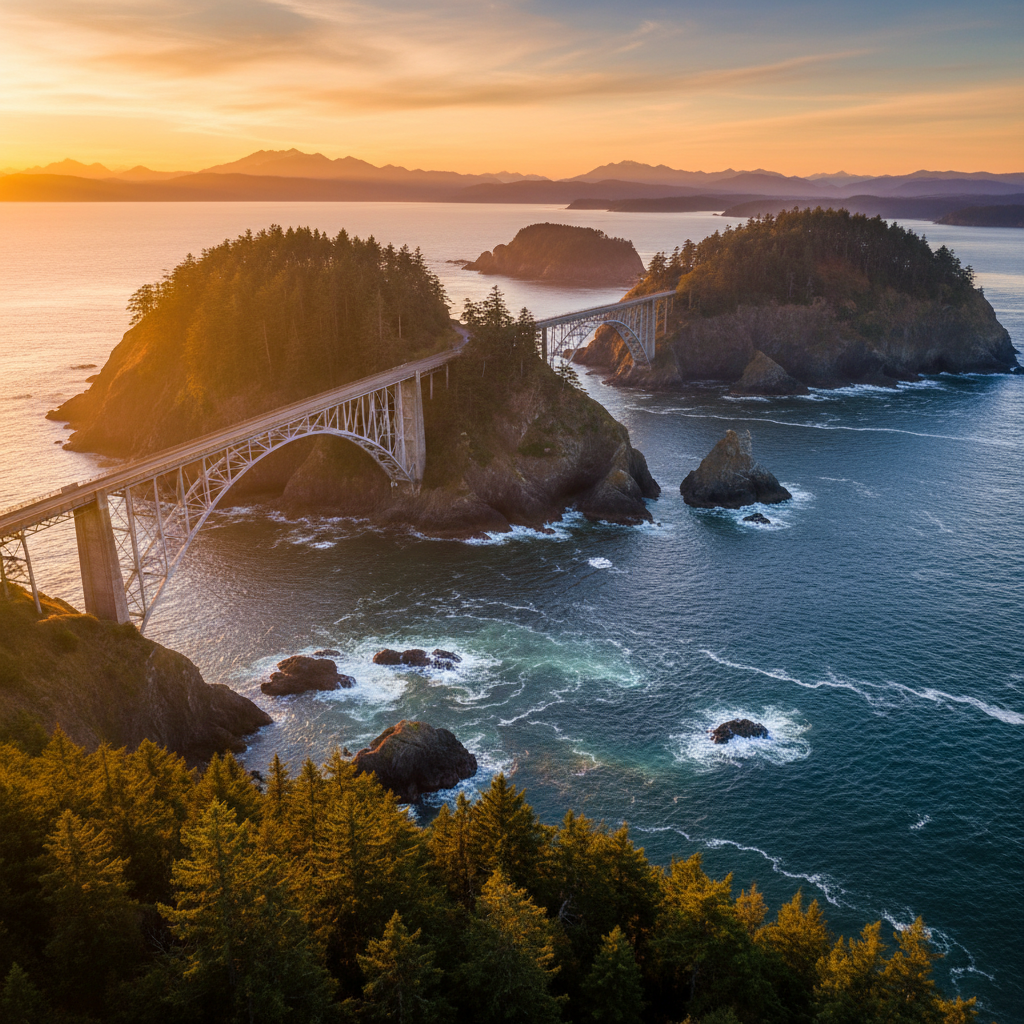
Captain Vancouver named it for the deception: what looked like a bay was actually a violent tidal strait. The bridge rises 180 feet above churning whirlpools that flush twice daily.
Deception Pass State Park spans 4,134 acres across the northern tip of Whidbey Island and the southern edge of Fidalgo Island, joined by a pair of historic steel cantilever bridges completed in 1935. The park is defined by the dramatic tidal strait of Deception Pass, where the waters of Skagit Bay and the Strait of Juan de Fuca collide. Standing on the pedestrian walkway of the Deception Pass Bridge, 180 feet above the water, you can feel the low rumble of traffic vibrating through the steel as wind funnels through the gorge. Below, millions of gallons of saltwater are forced through the narrow rock channel twice daily, creating massive, swirling whirlpools and roiling eddies that can easily swallow a small boat. Bald eagles frequently ride the thermals overhead, while harbor seals bob in the turbulent currents below, hunting for salmon.
The park's name originates from Captain George Vancouver, who in 1792 initially mistook the deep, turbulent channel for a closed bay, feeling 'deceived' when his expedition mapped the narrow passage. Long before British ships arrived, Coast Salish peoples, including the Samish and Swinomish, fished these waters and established villages along the shores, particularly at Rosario Beach. In the 1930s, the Civilian Conservation Corps established two camps here, carving out the park's roads, trails, and rustic log picnic shelters. CCC workers also built the historic bathhouse at Bowman Bay, which now serves as a dedicated interpretive center showcasing the tools, photographs, and personal stories of the young men who built the park's infrastructure during the Great Depression.
Exploring the park's diverse shoreline reveals a landscape of dramatic contrasts, from the rugged cliffs of Lighthouse Point to the quiet old-growth forests of Goose Rock. Hikers can follow the North Beach Trail from the bridge's south end down to the Whidbey Island shoreline, where the massive steel spans tower directly overhead, framing views of the Olympic Peninsula. On the Fidalgo Island side, the rocky bluffs of Rosario Head feature tide pools filled with bright green anemones, purple sea stars, and ochre crabs, while the nearby waters of Bowman Bay offer a protected cove for kayakers. Inland, the park protects three freshwater lakes, including the fly-fishing waters of Pass Lake and the popular swimming shores of Cranberry Lake, all surrounded by dense stands of Douglas fir, western red cedar, and twisted, red-barked madrona trees.
To witness the pass at its most dramatic, consult a local tide table and time your walk across the bridge during a peak tidal exchange, when the water speeds can exceed eight knots. To escape the bridge crowds, head to the Rosario Head tide pools at low tide to spot giant green anemones, or hike the quiet loop trail around Lighthouse Point on the Fidalgo side.