A high-altitude realm of glacier-scoured granite, alpine lakes, and wind-swept junipers, serving as the wild, protected backyard to Lake Tahoe.
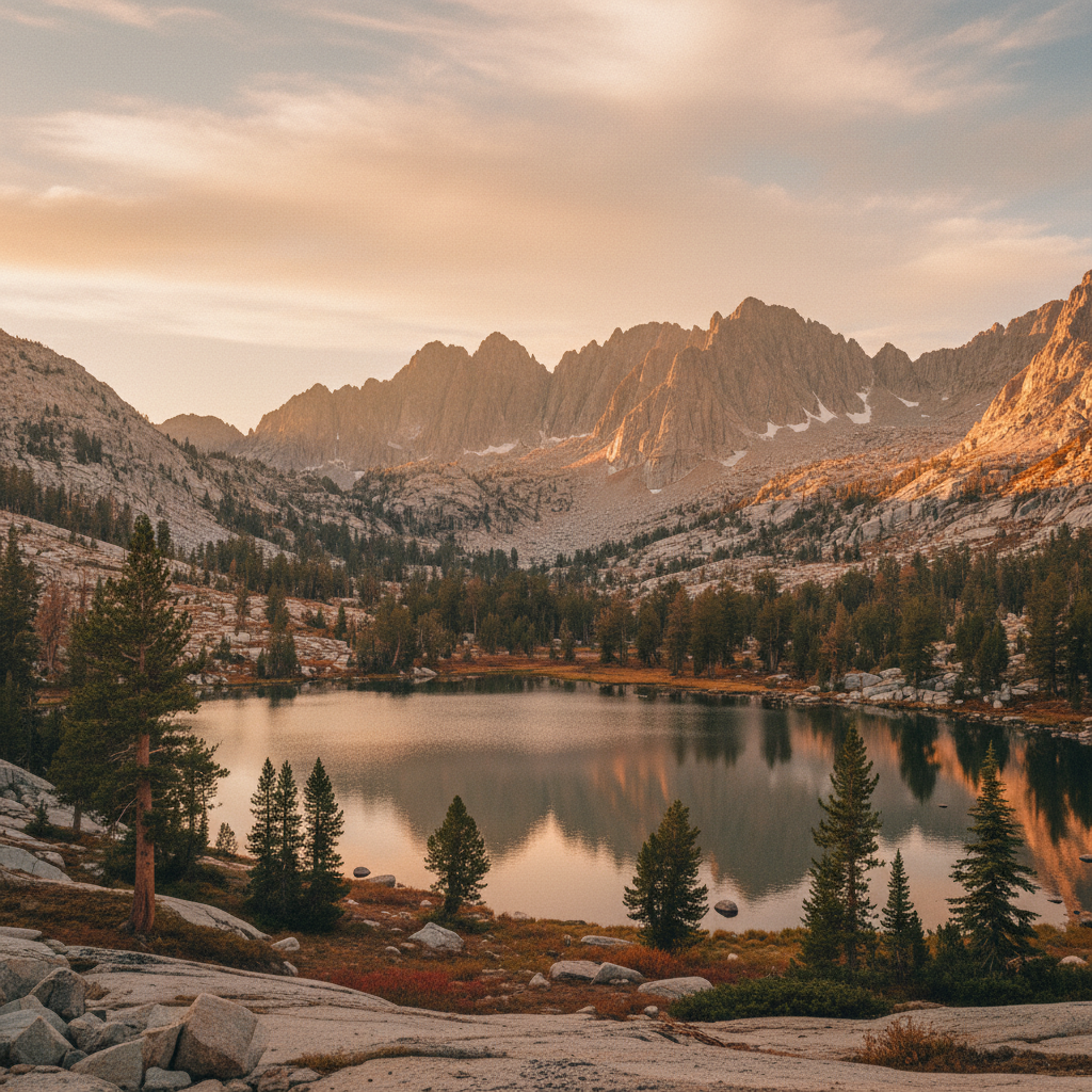
Desolation Wilderness spans 63,960 acres of subalpine forests, stark granite peaks, and glacially carved basins directly west of Lake Tahoe. Long before it was designated as a federal wilderness area in 1969, or set aside as a primitive area in 1931, these high-altitude basins were the seasonal home of the Wašiw (Washoe) people. For millennia, Wašiw families traveled up from the Carson Valley during the warm summer months, establishing temporary encampments at places like Wrights Lake to hunt, forage, and gather obsidian. Today, this protected landscape is co-managed by the Eldorado National Forest and the Lake Tahoe Basin Management Unit, preserving a starkly beautiful terrain shaped by the massive Sierra batholith. During the last ice age, glaciers more than 1,000 feet deep ground down the western slopes of the Sierra Nevada, leaving behind a legacy of polished granite, massive erratics, and more than 130 alpine lakes.
The heart of the wilderness is defined by its dramatic elevation changes, ranging from 6,500 feet to nearly 10,000 feet at the summit of Pyramid Peak. The Pacific Crest Trail and the Tahoe Rim Trail share a 17-mile corridor through this high country, crossing over Dicks Pass, which stands as the highest point on the trail within the wilderness at 9,380 feet. Along this route, hikers encounter Lake Aloha, a shallow, island-studded reservoir that sits like a massive sheet of glass against the backdrop of the sawtoothed Crystal Range. Other prominent water features include the nearly 500-foot Horsetail Falls, which cascades over steep granite benches near Highway 50, and the cluster of Velma Lakes, which draw backpackers seeking cold, clear waters bordered by lodgepole pines. The scent of Jeffrey pine and warm stone fills the lower elevations, eventually giving way to the sparse, wind-scoured ridges where gnarled western junipers cling to cracks in the granite.
Visiting this fragile alpine ecosystem requires careful preparation and a commitment to strict conservation rules. Because of its immense popularity and proximity to Lake Tahoe, the U.S. Forest Service enforces a strict quota system for overnight permits from the Friday before Memorial Day through September 30. Campfires are completely prohibited within the wilderness boundaries to protect the sparse timber, and backpackers must carry hard-sided, approved bear canisters to prevent encounters with local black bears. While popular trailheads like Eagle Falls and Echo Lakes draw heavy crowds on summer weekends, quieter entry points like the Lyons Creek Trailhead offer a more demanding but solitary route toward Lyons Lake and Sylvia Lake. For those navigating the granite slabs in the golden light of late September or listening to the sharp whistle of a yellow-bellied marmot across a boulder field, the true character of this landscape lies in its raw, elemental silence.
To bypass the crowded trailheads on the eastern side of the wilderness, secure an overnight permit for the Lyons Creek Trailhead off Highway 50. While the climb is steady and demanding, it rewards backpackers with relative solitude on the way to the granite-rimmed basins of Lyons Lake and Sylvia Lake. Plan a mid-week trip in late August or early September for fewer mosquitoes, golden late-season light, and a better chance of securing your first-choice camping zone.