An electric-turquoise alpine basin in the San Juan Mountains, framed by rugged 13,000-foot peaks and historic silver-mining remnants.
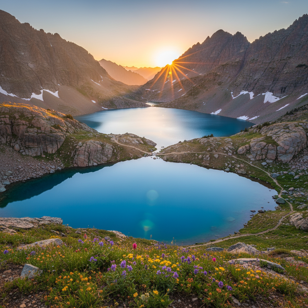
Ice Lakes Basin, situated within the San Juan National Forest near the historic mining town of Silverton, Colorado, is a spectacular high-alpine amphitheater carved by ancient glaciers and bordered by rugged peaks. The trail to the basin begins across from the South Mineral Campground at an elevation of 9,840 feet and climbs steadily through subalpine forests and meadows before reaching the lower basin at 11,400 feet. The final stretch to the upper basin is a demanding series of steep switchbacks that gains over 800 feet in less than a mile, testing the lungs of hikers in the thin air. Upon cresting the final grassy ridge at 12,270 feet, the landscape opens to reveal the striking, electric-turquoise water of Ice Lake. This brilliant coloration is the result of glacial flour, extremely fine rock dust suspended in the cold snowmelt that scatters light in the blue-green spectrum. The lake rests in a massive cirque flanked by the craggy summits of Vermilion Peak (13,894 feet), Golden Horn (13,765 feet), and Pilot Knob (13,738 feet), creating a dramatic contrast between the vibrant water and the crumbling red and grey volcanic rock.
The geological history of the basin is rooted in the violent eruptions of the San Juan volcanic field, which occurred around 30 million years ago and formed the massive Silverton Caldera. Subsequent glacial periods scoured these volcanic layers, leaving behind the deep bowls that now hold the basin's lakes. Before European-American mineral seekers arrived, these high-altitude valleys were the traditional homelands of the Nuuchiu (Ute) people, specifically the Tabeguache band, who navigated these rugged passes for seasonal hunting and gathering. The 1873 Brunot Agreement forced the Ute people to cede millions of acres in the San Juans, paving the way for the region's silver and gold mining boom. Hikers can still observe remnants of this era along the trail, including old mining prospects, rusted equipment, and tailings piles that cling to the steep slopes of the surrounding peaks, serving as silent monuments to the prospectors who labored in this harsh environment over a century ago.
Exploring beyond the main lake reveals a network of high-altitude tarns, each with its own distinct character and coloration. A steep, unmaintained social trail climbs northeast from Ice Lake to Island Lake, situated at 12,392 feet. This smaller, deeper green tarn features a prominent rock island in its center and sits in a stark, wind-scoured bowl that receives far fewer visitors than the lower basin. To the south, another trail winds toward Fuller Lake at 12,585 feet, passing near the ruins of an old mining cabin. During the fleeting summer months, which typically last only forty frost-free days from mid-July to late August, the tundra floor of the basin transforms into a dense carpet of wildflowers. Hikers will find vibrant displays of blue columbine, yellow alpine avens, purple sky pilot, and Indian paintbrush feeding on the abundant moisture from melting snowfields and cascading waterfalls.
Arrive at the trailhead across from South Mineral Campground by 6:00 AM to secure a parking spot and avoid the dangerous afternoon lightning storms that frequent the high ridges. Pack a water filter to refill at the lake, and if you have the energy, follow the faint trail climbing northeast to Island Lake for a quieter, deep-green perspective of the basin.