A high-altitude amphitheater of eroded red-rock hoodoos and ancient bristlecone pines, perched at 10,000 feet on the Markagunt Plateau.
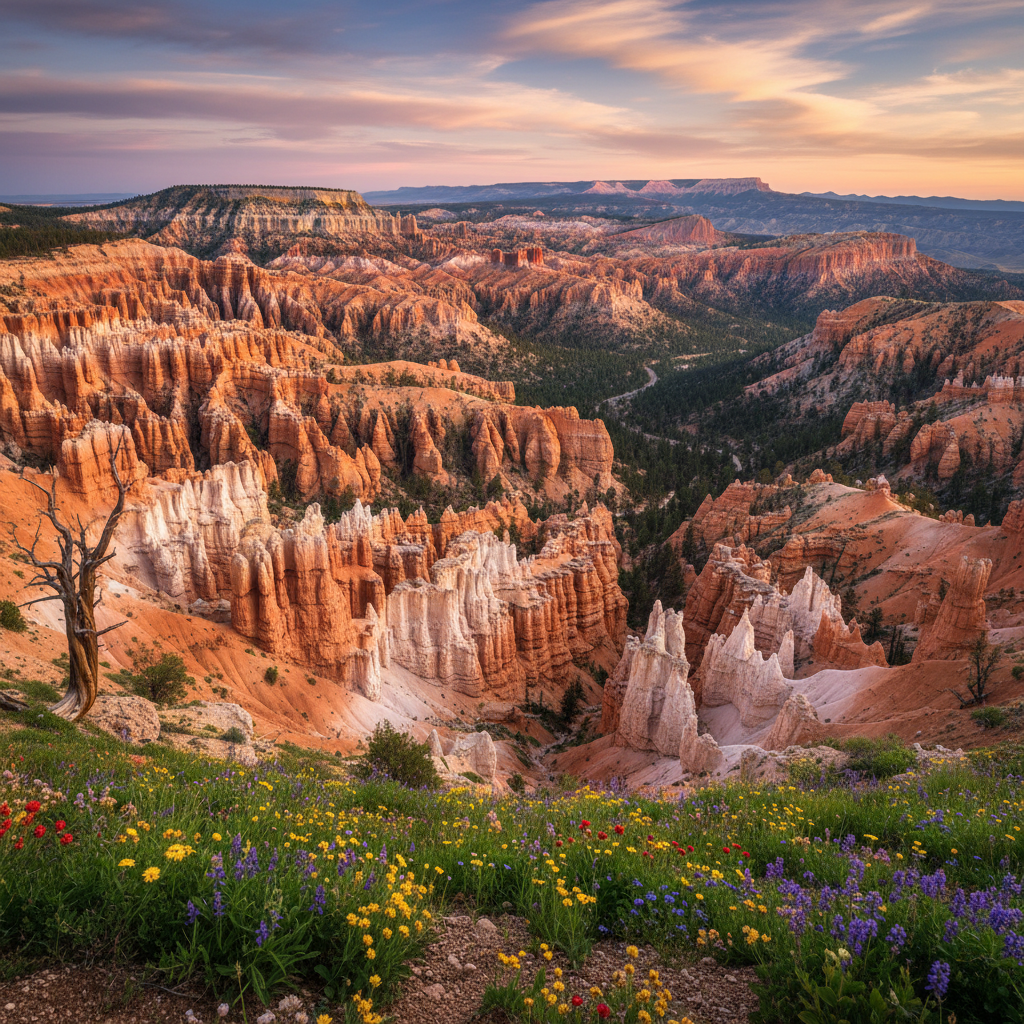
Cedar Breaks National Monument sits like a colossal, multi-colored amphitheater carved into the western edge of Utah's Markagunt Plateau, rising to an elevation of over 10,000 feet. Long before European settlers arrived, the Southern Paiute recognized the kinetic, ever-shifting nature of this landscape, calling it umapwich, which translates to "the place where the rocks are sliding down all the time". They also referred to it as Ungkaw Pekonump, meaning "red-cove". The modern name is actually a double misnomer: early Mormon settlers who arrived in the mid-nineteenth century mistook the local Utah junipers for cedar trees, and they used the term "breaks" to describe the steep, rugged badlands where the high plateau abruptly drops more than 2,000 feet into a half-mile-deep basin. Today, this high-altitude sanctuary remains far less crowded than its famous neighbor, Bryce Canyon National Park, yet it offers an intimacy and quietude that are increasingly rare in the American West.
The geologic heart of the monument is the Claron Formation, a sedimentary layer deposited roughly 50 million years ago at the bottom of a vast, ancient freshwater body known as Lake Claron. Over millions of years, streams carried sand, silt, and calcium-rich mud into the basin, where they compressed into limestone, siltstone, and sandstone. The vibrant, saturated palette of the amphitheater, a spectrum of deep ochre, brilliant rose, lavender, and stark white, is the result of iron and manganese impurities oxidizing within the stone, essentially rusting over eons. This fragile rock is constantly sculpted by a relentless freeze-thaw cycle, with water expanding in the joints during cold mountain nights and breaking away the softer stone. The resulting labyrinth of hoodoos, spires, and eroded fins is a dynamic work in progress, constantly shedding its skin under the influence of summer rains and winter snows.
Surrounding the rim is a delicate subalpine forest dominated by Engelmann spruce, subalpine fir, and ancient bristlecone pines, some of which have clung to these exposed cliffs for over fifteen hundred years. During the brief summer window, typically from late June through August, the meadows bordering the rim erupt in a dense carpet of wildflowers, celebrated during the annual Wildflower Festival: blue lupine, scarlet Indian paintbrush, Colorado columbine, and mountain bluebells paint the green hillsides. Visitors can explore this high-elevation world via the Spectra Point and Ramparts Overlook Trail, a scenic path that winds along the rim through old-growth forests to dramatic viewpoints. Near the south entrance, the Point Supreme Visitor Contact Station welcomes travelers, while the historic 1937 log cabin visitor center has been preserved as a museum dedicated to the human history of the plateau. As night falls, the monument transforms into a certified International Dark Sky Park, where the thin, high-altitude air reveals a brilliant canopy of stars and the Milky Way stretching across the silent stone amphitheater.
Prepare for the 10,000-foot altitude by packing layers and a rain jacket, even in mid-summer. Afternoon thunderstorms roll in quickly over the Markagunt Plateau, often bringing sudden temperature drops, hail, and lightning.