Jewel Basin's iconic, trail-accessible summit. 360-degree views of the Flathead and Swan ranges.
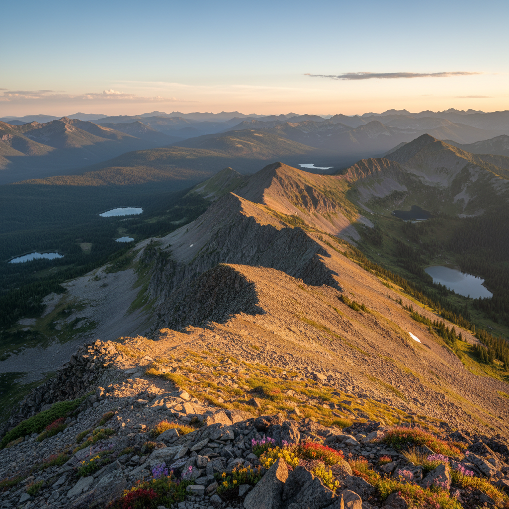
Mount Aeneas stands as the defining, trail-accessible crest of the Jewel Basin Hiking Area, a unique 15,349-acre preserve in the northern Swan Range of Flathead National Forest. Reaching an elevation of 7,510 feet, this limestone peak dominates the eastern skyline of the Flathead Valley. The journey to the summit begins at the Camp Misery trailhead, situated at a relatively high starting elevation of 5,500 feet. From here, hikers follow a network of trails, primarily Trail 717, which climbs steadily through subalpine forests of Engelmann spruce, lodgepole pine, and subalpine fir. In early summer, the forest floor is blanketed with white plumes of blooming beargrass and purple wildflowers. As the trail gains elevation, the dense canopy gives way to open slopes of fractured limestone, revealing expansive views of the valley below and the shimmering waters of Flathead Lake to the southwest.
Geologically, Mount Aeneas is a product of the dramatic Lewis Overthrust, where ancient Precambrian sedimentary rock of the Belt Supergroup was pushed eastward over younger strata, creating the sheer, rugged western faces that characterize the Swan Range. The peak is named in honor of Chief Aeneas Paul, a prominent leader of the Dayton Creek Kootenai who signed the Hell Gate Treaty of 1855 and served as an interpreter for Jesuit missionaries. This high-altitude landscape serves as a protected sanctuary for native wildlife, notably a robust population of mountain goats. These sure-footed animals are a frequent sight along the rocky ridges, often licking minerals from the limestone cliffs or resting on the high talus slopes. Golden eagles, mountain bluebirds, and migrating hawks frequently ride the powerful thermals rising from the deep valleys below, while hoary marmots echo their warning whistles across the rock fields.
The classic route to the summit follows the exposed northern ridge, a dramatic spine of rock where the ground drops away precipitously, offering an exhilarating sense of suspension between the earth and sky. At the summit, a historic stone windbreak built by early forest rangers provides a sheltered spot to absorb the panoramic vistas. To the north, the jagged, glacier-carved peaks of Glacier National Park pierce the horizon, while to the east, the vast, roadless expanse of the Bob Marshall Wilderness stretches toward the Great Plains. To complete the classic seven-mile loop, hikers can descend the steep north ridge to a high gap, dropping down a series of switchbacks on Trail 7 to the deep blue basins of the Picnic Lakes. This descent winds past pristine alpine waters before connecting with Trails 68 and 8 to return to Camp Misery, completing a journey that showcases the raw, undeveloped beauty of Northwest Montana.
To beat the summer crowds and afternoon thunderstorms, aim to be on the trail by 7:00 AM. Bring a windbreaker even in July, as the summit ridge is notoriously cold and gusty. Keep an eye out for mountain goats near the summit, but maintain a respectful distance of at least fifty yards to keep them and yourself safe.