Death Valley's sailing stones. Mysterious rock trails across an exceptionally flat, dry lakebed at the end of a rugged 28-mile dirt road.
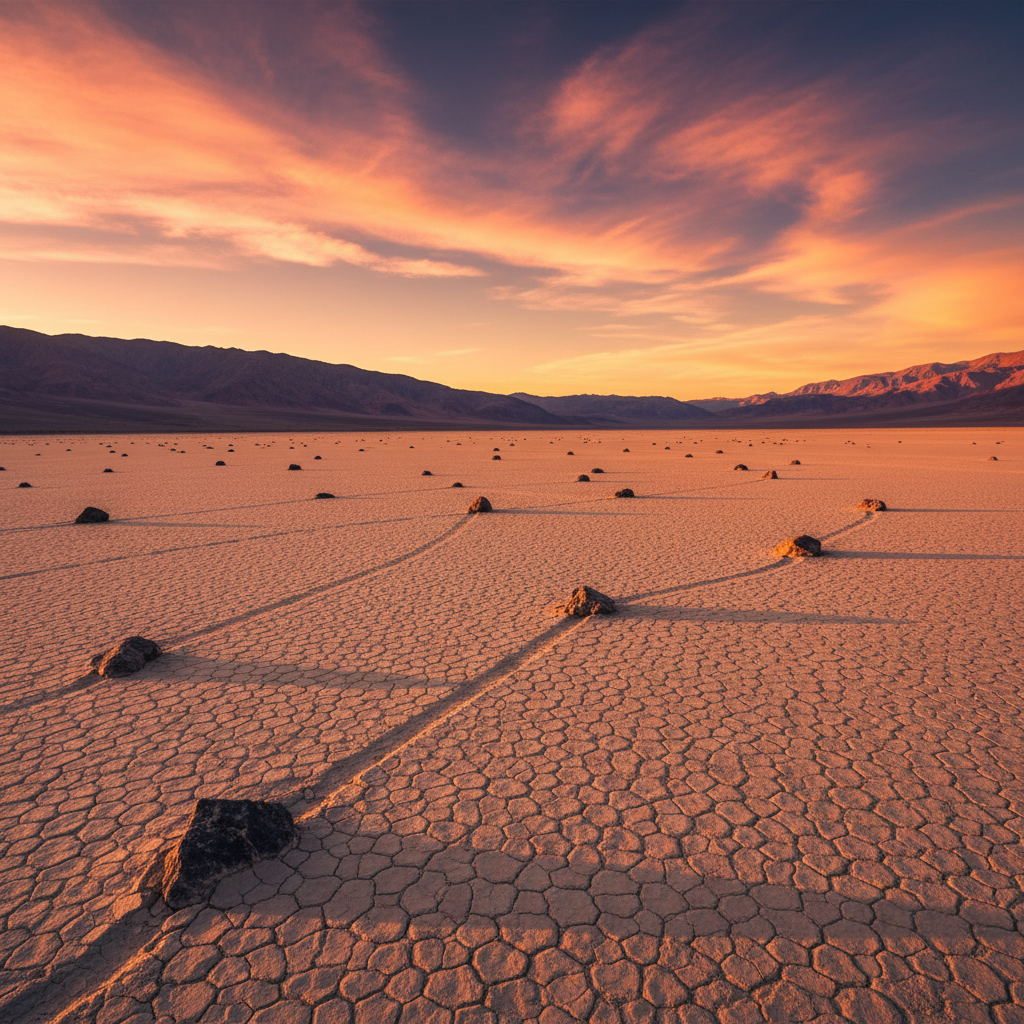
The Racetrack Playa sits at an elevation of 3,708 feet in a remote, wind-swept valley bounded by the Cottonwood and Last Chance ranges in Death Valley National Park. This dry lakebed, or playa, is nearly three miles long and over a mile wide, presenting one of the flattest natural surfaces on Earth: the northern end is only about two inches higher than the southern end. The ancestral homeland of the Timbisha Shoshone, who have lived in the region for at least a millennium, this landscape is defined by its parched, beige-colored mud floor, which is baked into a tight mosaic of polygonal desiccation cracks. Two main features break the flat expanse of the playa: the Grandstand, a dark-gray monolith of Jurassic-era quartz monzonite that juts 73 feet above the northern dry lakebed, and the legendary "sailing stones" that slowly drift across the southern basin, leaving shallow, winding furrows in the hard clay.
For decades, the movement of these stones, which range from small pebbles to massive dolomite blocks weighing up to 700 pounds, remained one of the desert's most enduring mysteries. Various theories blamed dust devils, algae films, or hurricane-force winds, but the mechanism was finally documented in late 2013 by researchers Richard Norris and James Norris through the Slithering Stones Research Initiative. Their research revealed that the stones move through a rare combination of winter elements. First, rare rains must flood the playa, creating a shallow pond. Freezing overnight temperatures then form a thin sheet of "windowpane" ice, usually only three to six millimeters thick. When the morning sun begins to melt the ice, light winds push these massive, floating sheets of ice across the shallow water, dragging the embedded rocks slowly across the mud beneath them at speeds of just a few inches per second.
Reaching this geological wonder requires navigating Racetrack Road, a grueling 28-mile unpaved track that begins near Ubehebe Crater. The journey is notorious for its sharp, tire-shredding rocks and heavy washboard corrugations, passing the whimsical landmark of Teakettle Junction at mile 20 before arriving at the northern end of the playa. Visitors should park at the southern end of the lakebed to view the highest concentration of sailing stones, which originate from the steep dolomite cliffs of the "Nursery" on the southeastern shore. Because the playa is incredibly fragile, off-road driving is strictly prohibited, and visitors must never walk on the surface when it is wet or muddy, as footprints can leave permanent scars that remain visible for decades.
A high-clearance vehicle with heavy-duty tires is essential, and carrying a spare tire (or two) is highly recommended. To see the highest concentration of sailing stones, walk to the southeastern corner of the playa, but never step on the mud if it is wet.