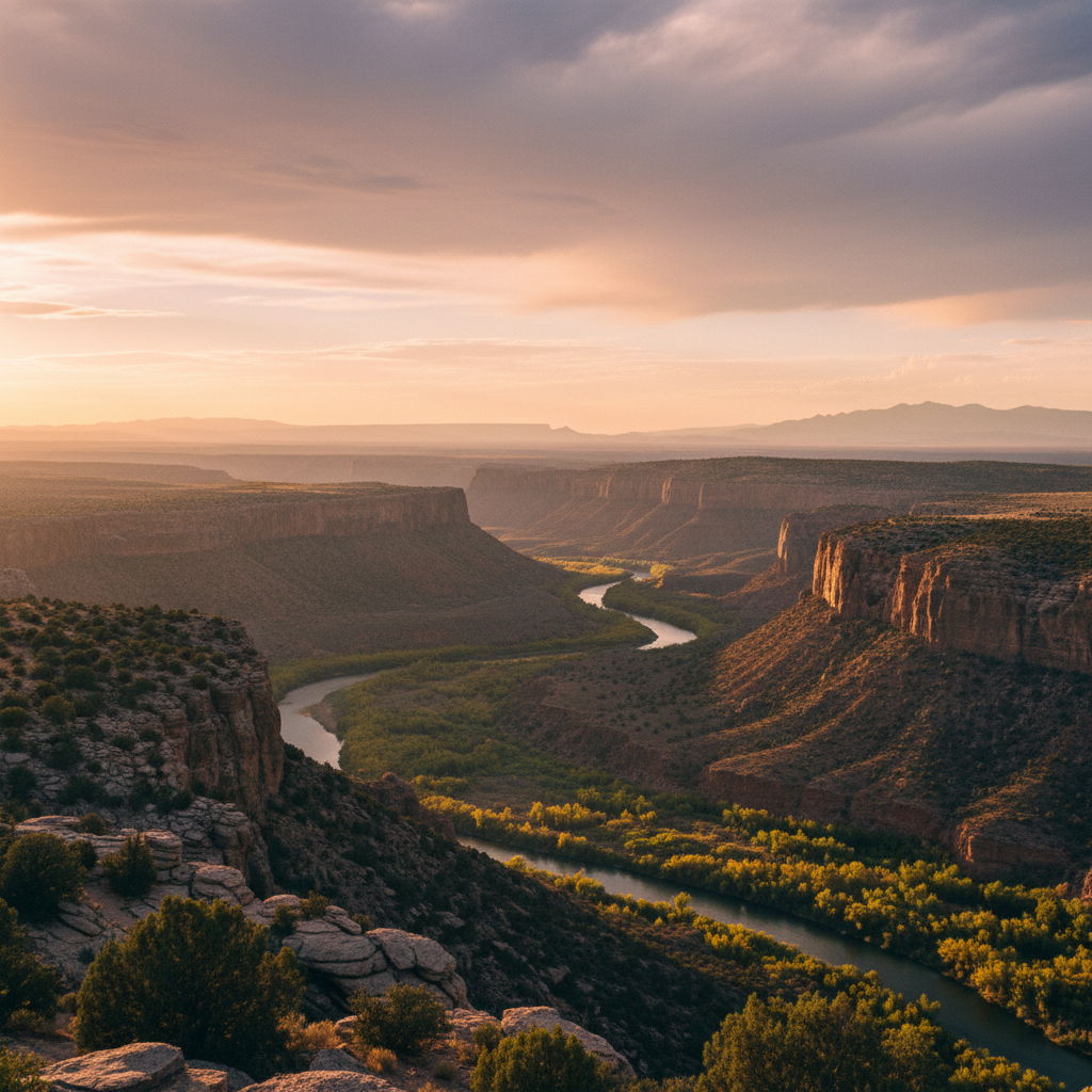
Wild Rivers Recreation Area marks the dramatic confluence of the Rio Grande and Red River, where the water cuts 800 feet deep through volcanic basalt. Hike from the sage-scented rim down to secluded riverbanks or look out from the edge of the Taos Plateau.
Wild Rivers Recreation Area is a rugged Bureau of Land Management sanctuary in northern New Mexico, positioned where the sage-brushed Taos Plateau abruptly fractures into a deep volcanic gorge. Located just north of Questa, the recreation area preserves the dramatic confluence of the Rio Grande and the Red River, both designated National Wild and Scenic Rivers. Standing at La Junta Point, which is fully wheelchair accessible, you look down 800 feet to watch the two distinct currents merge. The geology here is a stark, exposed record of the Rio Grande Rift, a continental tear where tectonic forces pulled the earth apart millions of years ago, leaving behind thick layers of dark volcanic basalt, ash, and gravel. To the north, the extinct volcanic cone of Ute Mountain, or La Yuta, dominates the horizon, serving as a historic landmark and weather indicator for local communities.
To experience the true scale of the canyon, you must leave the rim and descend into the gorge along one of several steep, demanding footpaths. The Big Arsenic Trail drops 680 feet over a mile of rocky switchbacks, leading hikers past ancient piñon and juniper trees, some of which have stood for over 500 years. Near the bottom, the trail passes Big Arsenic Springs, where cool, freshwater flows from the basalt rocks, creating a lush riparian oasis. Here, the dry desert air gives way to the damp scent of river water and rustling cottonwoods. These shaded depths provide crucial habitat for Rocky Mountain bighorn sheep, which navigate the near-vertical cliffs with ease, as well as mule deer, elk, and soaring red-tailed hawks. The Little Arsenic Trail offers a similarly strenuous descent, dropping 760 feet to the riverbanks where anglers cast for native Rio Grande cutthroat trout, German brown trout, and rainbow trout.
This dramatic landscape holds deep cultural significance as the ancestral homeland and traditional territory of the Taos Pueblo, Picuris Pueblo, Jicarilla Apache, and Ute peoples, who have traveled these canyon passages for millennia. Visitors can explore the rim via the 13-mile Wild Rivers Backcountry Byway, a paved loop road that connects the Wild Rivers Visitor Center to five small, primitive campgrounds, including Montoso, El Aguaje, and La Junta. These campgrounds offer simple amenities like covered picnic tables, fire pits, and vault toilets, though campers must bring their own water due to the area's remote nature and unreliable wells. As night falls, the high-elevation plateau becomes a premier destination for stargazing, with some of the darkest, most silent skies in the American Southwest, free from the glow of distant cities.
Since the La Junta Trail is closed due to rockfall, reach the majestic river confluence by descending the Little Arsenic Trail. This steep, one-mile trail drops 760 feet to the canyon floor, where you can connect with the relatively flat River Trail and hike south to the meeting of the Rio Grande and the Red River. Pack plenty of water, as the recreation area's water pumps are often out of service, and start your trek early in the morning to avoid the intense midday heat on the exposed basalt walls.