Towering granite spires and rounded domes rise above the Sacramento River at Castle Crags State Park, a rugged wilderness shaped by glaciers, rich Wintu history, and high-alpine trails.
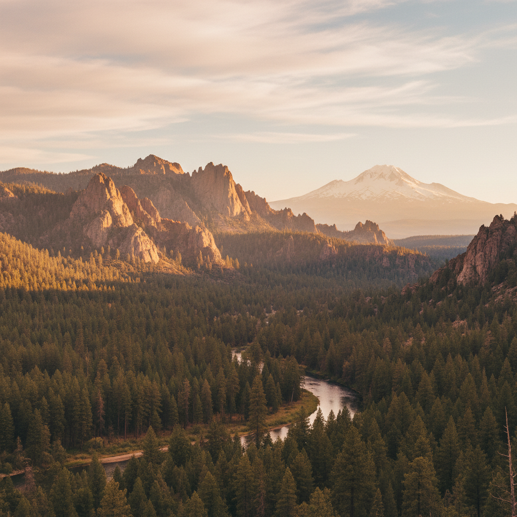
Castle Crags State Park encompasses a dramatic meeting of ancient geology and deep cultural history along the upper Sacramento River in Shasta County. The park is defined by its sheer, light-colored granite spires and domes, which rise abruptly to elevations over 6,500 feet, contrasting sharply with the surrounding dark, ultramafic serpentine soils of the Klamath Mountains. These formations began as a granitic pluton intruding deep underground roughly 170 million years ago during the Jurassic period. Over millennia, Pleistocene glaciers and relentless weathering stripped away the softer overlying rock, leaving the resilient granite peaks exposed to the sky. For thousands of years, the Okwanuchu Shasta, Wintu, Achumawi, and Modoc peoples lived in the shadow of these peaks, holding the entire landscape, its cold mountain springs, and the river as sacred ground. While early European fur traders and Spanish explorers labeled the formations "Castle del Diablo" or "Devil's Castle," the local Wintu people maintained a profound spiritual connection to the high-vibrational peaks, viewing them as a sanctuary of the spirits.
The modern history of the park is marked by the tumultuous events of the California Gold Rush, which brought thousands of miners into the region. This influx culminated in the 1855 Battle of Castle Crags at Battle Rock, a clash precipitated by the destruction of the Wintu people's vital salmon runs and hunting grounds. Recognizing the ecological and scenic value of the area, concerned citizens rallied in 1933 to acquire the land, officially establishing Castle Crags State Park to protect it from rampant logging and mining. Today, the park serves as a gateway to both state-managed forests and the adjacent 10,500-acre Castle Crags Wilderness within the Shasta-Trinity National Forest. Visitors can base their explorations at one of the park's 76 developed campsites, which are situated amid a dense canopy of ponderosa pine, Douglas fir, incense cedar, and black oak. These sites offer convenient access to the rushing waters of the Sacramento River, where anglers cast for wild trout and hikers seek shade in the warm summer months.
Exploring the park means navigating a diverse network of trails, including an eight-mile stretch of the Pacific Crest Trail that winds through the property. For a gentle walk, the accessible, one-mile Root Creek Trail meanders through a cool, forested canyon to a year-round flowing stream and distant views of cascades. Those seeking a rugged ascent can take the strenuous Crags Trail, which climbs more than 2,200 vertical feet over a 5.5-mile round-trip to the base of Castle Dome. This grueling hike transitions from shaded mixed-conifer forest to exposed, gritty granite slabs, where the endemic Castle Crags harebell clings to rocky crevices alongside rare Brewer spruce. Reaching the base of the massive, 4,996-foot granite dome rewards hikers with a sweeping panorama of the winding Sacramento River canyon and the immense, snow-capped mass of Mount Shasta dominating the northern horizon.
Avoid the midday heat on the exposed granite by starting the strenuous hike to Castle Dome at dawn, making sure to detour to the shaded oasis of Indian Springs for a cold splash of fresh water. Afterward, cool off with a swim in the Sacramento River near the park's Riverside picnic area.