Stand on a sheer sandstone peninsula towering two thousand feet above a dramatic gooseneck curve of the Colorado River, where the vast desert sky meets the red rock canyons of Utah.
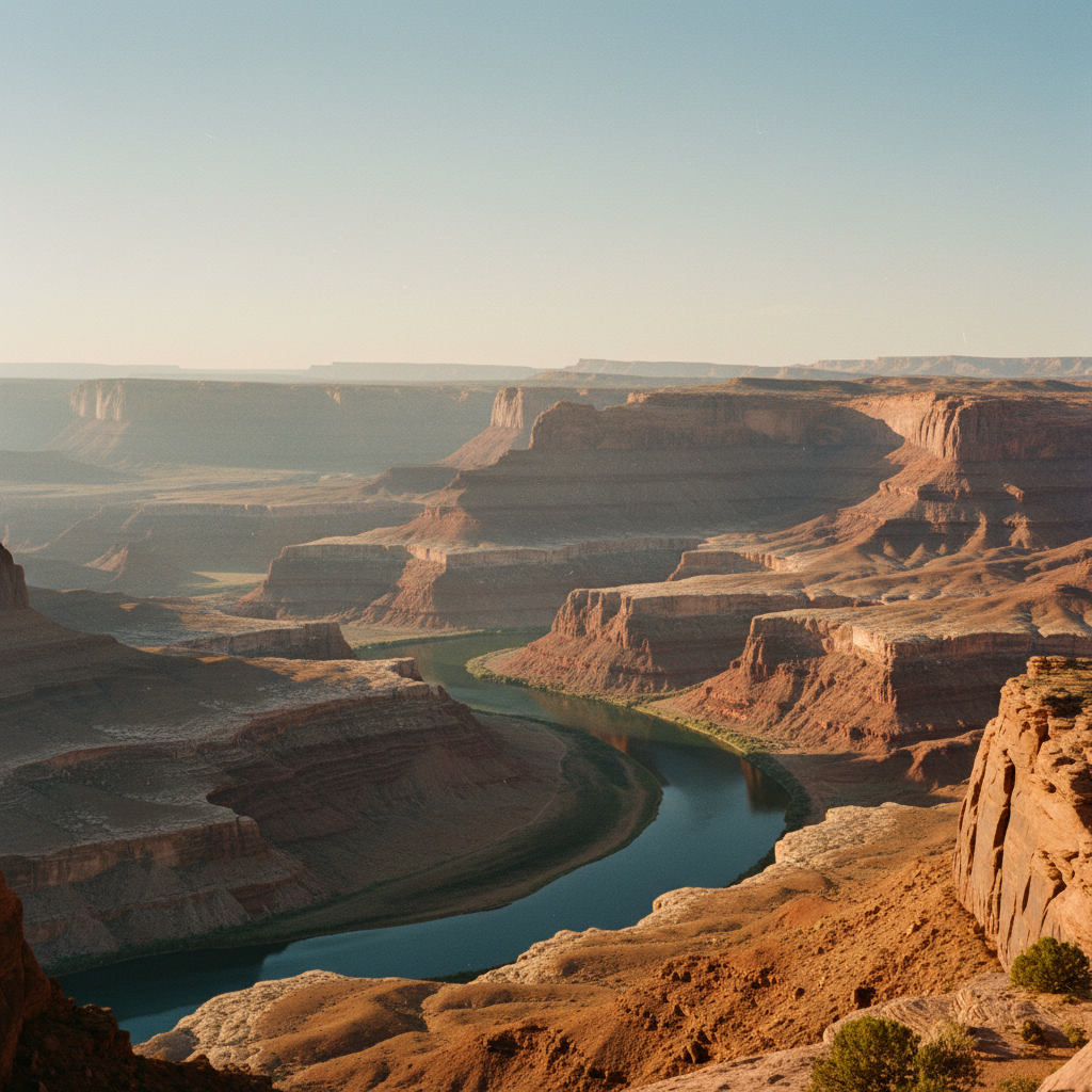
Dead Horse Point State Park sits atop a towering sandstone peninsula in southeastern Utah, suspended two thousand feet above a dramatic gooseneck curve of the Colorado River. This high-desert mesa, capped by the resistant ledges of the Jurassic Kayenta Formation, offers a sheer vertical drop that looks down onto 300 million years of exposed geologic history. From the overlook, the vast canyon country unfolds in a dizzying maze of rust-colored cliffs, pinnacles, and flat-topped mesas. Far below, the river makes a monumental U-turn around a massive rock gooseneck, its waters glinting in the desert sun. In the distance, the electric-blue potash evaporation ponds of the Intrepid Potash mine sit like tiny chips of stained glass dropped onto the canyon floor. The wind up here is a constant companion, carrying the dry scent of Utah juniper and pinyon pine, while the deep silence of the canyon country is broken only by the occasional call of a raven riding the thermals.
Established as a state park in 1959, the 5,362-acre reserve preserves a landscape deeply intertwined with both human history and folklore. The park's somber name originates from the late 19th century, when cowboys used the narrow, thirty-yard neck of the mesa as a natural corral to trap wild mustangs. According to local lore, a band of horses was once left corralled on the waterless promontory, unable to find their way off, and perished within sight of the Colorado River far below. Long before the cowboys, Ancestral Puebloan people hunted and gathered across these mesas, leaving behind stone tools and artifacts that are now preserved in the park. In the visitor center, the semi-permanent exhibition "Spirit & Grit", developed in partnership with the Moab Museum, chronicles this hardscrabble ranching and settlement history. More recently, the park's dramatic cliffs served as the cinematic stand-in for the Grand Canyon in the final, iconic scene of the 1991 film *Thelma & Louise*, forever cementing this specific overlook in modern American pop culture.
Exploring the park on foot reveals a diverse network of paths, including the East Rim and West Rim trails, which hug the sheer cliffs and offer unobstructed views of the canyon system. To the east, the snow-capped peaks of the La Sal Mountains rise like white sails over the red desert, while to the west, the flat-topped mesas of Canyonlands National Park stretch toward the horizon. Mountain bikers can ride the Intrepid Trail System, a 16.6-mile network of singletrack loops like Great Pyramid and Big Chief that wind through the desert crust, with an additional six miles of mixed-use trails added to the far east rim in 2025. Overnight visitors can camp at the Kayenta Campground, which features 21 paved sites with electrical hookups, or the newer Wingate Campground, which offers RV sites, walk-in tent sites, and four yurts. Five additional yurts are available at the Moenkopi yurt area near the park entrance. Designated an International Dark Sky Park in 2016, the mesa top undergoes a spectacular transformation after sunset, as the canyon walls fade from deep ochre to bruised purple, and the sky becomes a brilliant canopy of stars where the Milky Way arches clearly from rim to rim.
Arrive before dawn and walk the East Rim Trail to watch the sunrise illuminate the La Sal Mountains in quiet solitude, long before the sunset crowds pack the main overlook. For mountain bikers, Bighorn Mountain Biking operates directly out of the Intrepid Trailhead, offering on-site mountain bike and e-bike rentals so you do not have to haul gear from Moab.