Lipan Point offers an expansive South Rim vista featuring the longest visible stretch of the Colorado River, the ancient tilted strata of the Grand Canyon Supergroup, and the churning white water of Hance Rapid.
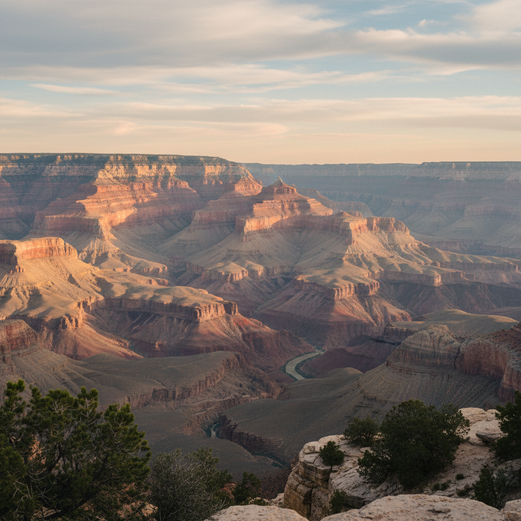
Lipan Point stands as one of the most geographically revealing overlooks on the South Rim of the Grand Canyon, positioned at an elevation of 7,360 feet. Located along Desert View Drive, approximately 6 miles west of the Desert View Watchtower and 23 miles east of Grand Canyon Village, this rocky promontory provides a panoramic vista that encompasses some of the widest expanses of the entire canyon. Unlike many other South Rim viewpoints where the Colorado River remains obscured within deep, narrow slots, this specific vantage reveals a long, curving stretch of the river winding through the inner gorge. From the paved overlook, which is secured by sturdy guardrails and equipped with interpretive panels, visitors can look down to trace nearly a mile of the river's path, including the churning white foam of Hance Rapid, one of the canyon's most formidable whitewater runs.
The primary geological distinction of Lipan Point is its unobstructed view of the Grand Canyon Supergroup, a rare sequence of tilted sedimentary and volcanic rock layers that are elsewhere buried or entirely eroded away. These ancient strata, tilted at a sharp angle beneath the flat Paleozoic layers above them, date back between 1.25 billion and 729 million years. From the rim, observers can clearly distinguish the reddish hues of the Dox Formation, the dark band of the Cardenas Basalt, and the Hakatai Shale. These tilted layers are separated from the overlying Tapeats Sandstone by the Great Unconformity, an immense geological gap representing hundreds of millions of years of missing history. Directly below these ancient layers lies the Unkar Delta, a broad river terrace where ancestral Puebloan peoples cultivated corn, beans, and squash around 1150 CE. Modern research and archaeological sources have identified this delta as a major center of prehistoric agricultural life within the canyon depths.
In addition to its geological and archaeological prominence, Lipan Point serves as a gateway to the rugged wilderness of the inner canyon. Just before the forty-space parking lot, the trailhead for the historic Tanner Trail descends precipitously toward the river. This unmaintained, ten-mile path was historically utilized by Hopi and Navajo travelers, and later by nineteenth-century miners and outlaws seeking a remote crossing. For those remaining on the rim, the point is a premier location for wildlife observation, particularly during the autumn raptor migration when hawks, eagles, and California condors ride the powerful thermal updrafts rising from the gorge. Because of its easterly position along Arizona Highway 64, the overlook generally escapes the dense crowds found near the main visitor center, offering a quieter space to watch the late-afternoon shadows of the South Rim slowly climb the temples and buttes of the North Rim.
Bring binoculars and arrive about 45 minutes before sunset to secure one of the forty parking spots at Lipan Point. Use the lenses to trace the white water of Hance Rapid and the ancient agricultural fields of the Unkar Delta down on the canyon floor, then look northeast to see Mary Colter's Desert View Watchtower silhouetted against the Painted Desert.